
Faire un don
Équipez-vous pour votre prochaine aventure :
En tant que Partenaire Amazon, ce site perçoit une commission sur les achats éligibles sans surcoût pour vous.
Carte topographique Castle Gresley
Cliquez sur la carte pour afficher l’altitude.
Faire un don
Équipez-vous pour votre prochaine aventure :
En tant que Partenaire Amazon, ce site perçoit une commission sur les achats éligibles sans surcoût pour vous.
À propos de cette carte
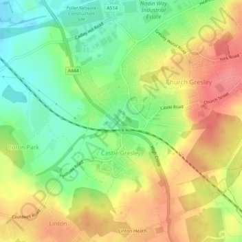
Nom : Carte topographique Castle Gresley, altitude, relief.
Altitude moyenne : 96 m
Altitude minimum : 59 m
Altitude maximum : 132 m
Faire un don
Équipez-vous pour votre prochaine aventure :
En tant que Partenaire Amazon, ce site perçoit une commission sur les achats éligibles sans surcoût pour vous.
Autres cartes topographiques
Cliquez sur une carte pour visualiser sa topographie, son altitude et son relief.
Robin Wood
United Kingdom > England > Derbyshire > South Derbyshire > Stanton by Bridge CP
Altitude moyenne : 92 m
Pistern Hill
United Kingdom > England > Derbyshire > South Derbyshire > Smisby
Altitude moyenne : 152 m
Repton Shrubs
United Kingdom > England > Derbyshire > South Derbyshire > Repton CP
Altitude moyenne : 110 m
Faire un don
Équipez-vous pour votre prochaine aventure :
En tant que Partenaire Amazon, ce site perçoit une commission sur les achats éligibles sans surcoût pour vous.
Newhall Wood
United Kingdom > England > Derbyshire > South Derbyshire > Newhall
Altitude moyenne : 87 m
Staunton Harold Reservoir
United Kingdom > England > Derbyshire > South Derbyshire > Melbourne CP
Altitude moyenne : 93 m
Faire un don
Équipez-vous pour votre prochaine aventure :
En tant que Partenaire Amazon, ce site perçoit une commission sur les achats éligibles sans surcoût pour vous.
Foremark Reservoir
United Kingdom > England > Derbyshire > South Derbyshire > Foremark CP
Altitude moyenne : 119 m
Botany Bay
United Kingdom > England > Derbyshire > South Derbyshire > Rosliston
Altitude moyenne : 95 m
Faire un don
Équipez-vous pour votre prochaine aventure :
En tant que Partenaire Amazon, ce site perçoit une commission sur les achats éligibles sans surcoût pour vous.
Mercia Marina
United Kingdom > England > Derbyshire > South Derbyshire > Willington CP
Altitude moyenne : 51 m
Faire un don
Équipez-vous pour votre prochaine aventure :
En tant que Partenaire Amazon, ce site perçoit une commission sur les achats éligibles sans surcoût pour vous.
Linton Heath
United Kingdom > England > Derbyshire > South Derbyshire > Linton
Altitude moyenne : 101 m
Gorsey Leys
United Kingdom > England > Derbyshire > South Derbyshire > Stanton by Bridge CP
Altitude moyenne : 101 m
Faire un don
Équipez-vous pour votre prochaine aventure :
En tant que Partenaire Amazon, ce site perçoit une commission sur les achats éligibles sans surcoût pour vous.
Elvaston Castle
United Kingdom > England > Derbyshire > South Derbyshire > Elvaston
Altitude moyenne : 41 m
Calke Park (National Trust)
United Kingdom > England > Derbyshire > South Derbyshire > Calke CP
Altitude moyenne : 98 m
Faire un don
Équipez-vous pour votre prochaine aventure :
En tant que Partenaire Amazon, ce site perçoit une commission sur les achats éligibles sans surcoût pour vous.