
Carte topographique Port of Spain
Carte interactive
Cliquez sur la carte pour afficher l’altitude.
À propos de cette carte
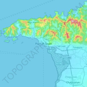
Nom : Carte topographique Port of Spain, altitude, relief.
Lieu : Port of Spain, 170605, Trinidad and Tobago (10.49727 -61.67802 10.81727 -61.35802)
Altitude moyenne : 59 m
Altitude minimum : -2 m
Altitude maximum : 905 m
Some of the city lies on land reclaimed from the Gulf of Paria, the calm sheltered bay separating Trinidad from Venezuela, while other parts climb into the hills above the city. Geographically, the Port of Port of Spain is ideal for maritime traffic, providing a natural harbour on Trinidad's north-western coasts where adverse weather conditions are extremely rare. Unlike Chaguanas and San Fernando, Port of Spain has a cool climate due to elevation and the surrounding Northern Range mountains. In the high, misty valleys and mountains that surround the northern outskirts of the city, temperature inversion is quite frequent and the mountains provide a cooling relief from the sweltering heat below. Blue Basin falls, a popular attraction, is located north in Diego Martin. This is the closest waterfall and is invigorating and refreshing.