
Carte topographique Nozawaonsen
Carte interactive
Cliquez sur la carte pour afficher l’altitude.
À propos de cette carte
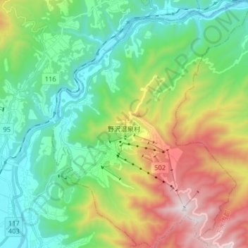
Nom : Carte topographique Nozawaonsen, altitude, relief.
Altitude moyenne : 710 m
Altitude minimum : 278 m
Altitude maximum : 1 635 m
Nozawaonsen is located in mountainous northeastern Nagano Prefecture, about one hour's drive from Nagano City. To the south it borders Kijimadaira along the ridge of Mount Kenashi. To the west side the Chikuma River, the longest river in Japan, which forms a border of the village with the city of Iiyama. The north and the east borders Sakae village. The altitude of Nozawaonsen ranges from 300m above sea level at the lowest, to about 600m in the village, and 1,650m at the peak of Mount Kenashi.
Autres cartes topographiques
Cliquez sur une carte pour visualiser sa topographie, son altitude et son relief.
Yamanouchi
Yamanouchi, Shimotakai County, Nagano Prefecture, Japan
Altitude moyenne : 942 m
Biwa Lake
Japan > Shimotakai County > Yamanouchi
Biwa Lake, Yamanouchi, Shimotakai County, Nagano Prefecture, Japan
Altitude moyenne : 1 368 m