
Carte topographique Catterall
Carte interactive
Cliquez sur la carte pour afficher l’altitude.
À propos de cette carte
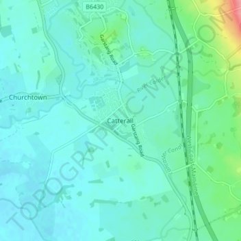
Nom : Carte topographique Catterall, altitude, relief.
Altitude moyenne : 22 m
Altitude minimum : 7 m
Altitude maximum : 96 m
Autres cartes topographiques
Cliquez sur une carte pour visualiser sa topographie, son altitude et son relief.
Churchtown
United Kingdom > England > Lancashire > Borough of Wyre
Churchtown, Borough of Wyre, Lancashire, England, PR3 0LQ, United Kingdom
Altitude moyenne : 15 m