
Carte topographique Bompensiere
Carte interactive
Cliquez sur la carte pour afficher l’altitude.
À propos de cette carte
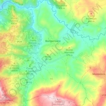
Nom : Carte topographique Bompensiere, altitude, relief.
Lieu : Bompensiere, Caltanissetta, Sicily, 93010, Italy (37.43393 13.75927 37.49893 13.81269)
Altitude moyenne : 319 m
Altitude minimum : 154 m
Altitude maximum : 583 m
The town is arranged along a single main street on whose sides the houses are divided, almost uniformly distributed. The lowest point of the town is to the north-west, at an altitude of about 270 meters above sea level (Piana Giarre); the highest point is located in the south-east at an altitude of about 320 meters above sea level (Contrada Portella).
Autres cartes topographiques
Cliquez sur une carte pour visualiser sa topographie, son altitude et son relief.
Mussomeli
Italy > Sicily > Caltanissetta
Mussomeli, Caltanissetta, Sicily, 93014, Italy
Altitude moyenne : 420 m
Caltanissetta
Italy > Sicily > Caltanissetta
Caltanissetta, Sicily, 93100, Italy
Altitude moyenne : 428 m