
Carte topographique Kreuzbach
Carte interactive
Cliquez sur la carte pour afficher l’altitude.
À propos de cette carte
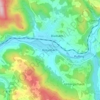
Nom : Carte topographique Kreuzbach, altitude, relief.
Altitude moyenne : 453 m
Altitude minimum : 379 m
Altitude maximum : 631 m
Autres cartes topographiques
Cliquez sur une carte pour visualiser sa topographie, son altitude et son relief.
Walderbach
Deutschland > Bayern > Landkreis Cham
Walderbach, Walderbach (VGem), Landkreis Cham, Bayern, 93194, Deutschland
Altitude moyenne : 426 m