
Carte topographique Blaichach
Carte interactive
Cliquez sur la carte pour afficher l’altitude.
À propos de cette carte
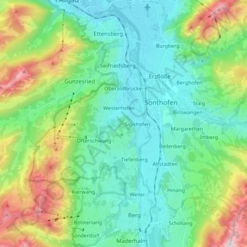
Nom : Carte topographique Blaichach, altitude, relief.
Lieu : Blaichach, Landkreis Oberallgäu, Bavaria, 87544, Germany (47.45411 10.10468 47.55401 10.26695)
Altitude moyenne : 1 003 m
Altitude minimum : 713 m
Altitude maximum : 1 814 m
Autres cartes topographiques
Cliquez sur une carte pour visualiser sa topographie, son altitude et son relief.
Bischlags
Germany > Bavaria > Landkreis Oberallgäu > Seebach
Bischlags, Seebach, Haldenwang, Landkreis Oberallgäu, Bavaria, 87490, Germany
Altitude moyenne : 740 m
Ellensberg
Germany > Bavaria > Landkreis Oberallgäu > Lauben
Ellensberg, Lauben, Landkreis Oberallgäu, Bavaria, Germany
Altitude moyenne : 673 m
Immenstadt im Allgäu
Germany > Bavaria > Landkreis Oberallgäu
Immenstadt im Allgäu, Landkreis Oberallgäu, Bavaria, 87509, Germany
Altitude moyenne : 918 m