
Carte topographique Docking
Carte interactive
Cliquez sur la carte pour afficher l’altitude.
Docking
Docking village in the centre of the parish is situated at an elevation of 82.7 metres (272 feet), which makes it one of the highest in Norfolk. It is surrounded by arable farmland having little woodland and is a nucleated settlement, with only one historical hamlet associated with it. This is Summerfield to the north-west, the site of a separate medieval village. The two modern hamlets in the parish are Burntstalk to the west around the former workhouse, and Docking Common to the south-east which postdates the enclosure of the village common in 1859.
À propos de cette carte
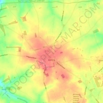
Nom : Carte topographique Docking, altitude, relief.
Altitude moyenne : 63 m
Altitude minimum : 20 m
Altitude maximum : 94 m
Autres cartes topographiques
Cliquez sur une carte pour visualiser sa topographie, son altitude et son relief.