
Carte topographique Harvey County
Carte interactive
Cliquez sur la carte pour afficher l’altitude.
À propos de cette carte
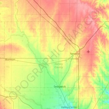
Nom : Carte topographique Harvey County, altitude, relief.
Lieu : Harvey County, Kansas, United States of America (37.91232 -97.70182 38.17457 -97.15257)
Altitude moyenne : 442 m
Altitude minimum : 409 m
Altitude maximum : 479 m
Autres cartes topographiques
Cliquez sur une carte pour visualiser sa topographie, son altitude et son relief.
Lansing
United States of America > Kansas > Lansing
Lansing, Leavenworth County, Kansas, 66043, United States of America
Altitude moyenne : 266 m
Oakley
United States of America > Kansas > Oakley
Oakley, Logan County, Kansas, 67748, United States of America
Altitude moyenne : 930 m
Pawne River
United States of America > Kansas
Pawne River, Hodgeman County, Kansas, United States of America
Altitude moyenne : 725 m
Earlton
United States of America > Kansas > Earlton
Earlton, Neosho County, Kansas, United States of America
Altitude moyenne : 292 m
Horton
United States of America > Kansas > Horton
Horton, Brown County, Kansas, United States of America
Altitude moyenne : 327 m
Winifred
United States of America > Kansas > Winifred
Winifred, Marshall County, Kansas, United States of America
Altitude moyenne : 378 m
Sawyer
United States of America > Kansas > Sawyer
Sawyer, Pratt County, Kansas, United States of America
Altitude moyenne : 582 m
Norton County
United States of America > Kansas
Norton County, Kansas, United States of America
Altitude moyenne : 719 m