
Carte topographique Western Ghats
Carte interactive
Cliquez sur la carte pour afficher l’altitude.
À propos de cette carte
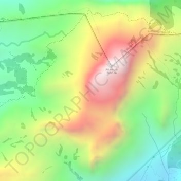
Nom : Carte topographique Western Ghats, altitude, relief.
Lieu : Western Ghats, Idukki, Kerala, 685614, India (10.16595 77.05795 10.16605 77.05805)
Altitude moyenne : 2 225 m
Altitude minimum : 1 828 m
Altitude maximum : 2 685 m
The range starts near south of the Tapti river and runs approximately 1,600 km (990 mi) through the states of Gujarat, Maharashtra, Karnataka, Goa, Kerala and Tamil Nadu ending at Marunthuvazh Malai, Swamithope near the southern tip of India. These hills cover 160,000 km2 (62,000 sq mi) and form the catchment area for complex riverine drainage systems that drain almost 40% of India. The Western Ghats block the southwest monsoon winds from reaching the Deccan Plateau. The average elevation is around 1,200 m (3,900 ft).
Autres cartes topographiques
Cliquez sur une carte pour visualiser sa topographie, son altitude et son relief.
chithirapuram
chithirapuram, Devikulam, Idukki, Kerala, India
Altitude moyenne : 940 m
Pond at Kesavan Purayidom, Kanjikuzhy
Pond at Kesavan Purayidom, Kanjikuzhy, Idukki, Kerala, India
Altitude moyenne : 639 m
Meesapulimala
Meesapulimala, Idukki, Kerala, 685618, India
Altitude moyenne : 2 221 m