
Carte topographique Chakan
Carte interactive
Cliquez sur la carte pour afficher l’altitude.
À propos de cette carte
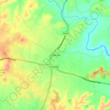
Nom : Carte topographique Chakan, altitude, relief.
Lieu : Chakan, Khed, Pune, Maharashtra, 410500, India (18.72231 73.82254 18.80231 73.90254)
Altitude moyenne : 624 m
Altitude minimum : 568 m
Altitude maximum : 712 m
Shiroli Chandus village, located 6 km north of Chakan, had been identified as the probable site for the proposed Pune International Airport, but due to the protests by the villagers & uneven topography, the site has been shifted to Purandar.
Autres cartes topographiques
Cliquez sur une carte pour visualiser sa topographie, son altitude et son relief.
Bhimashankar
India > Maharashtra > Khed
Bhimashankar, Khed, Pune, Maharashtra, India
Altitude moyenne : 749 m
Balshigwadi
India > Maharashtra > Khed > Awlewadi
Balshigwadi, Awlewadi, Khed, Maharashtra, India
Altitude moyenne : 735 m
Bhimashankar
India > Maharashtra > Khed > Bhimashankar
Bhimashankar, Khed, Maharashtra, India
Altitude moyenne : 741 m
Kiwale
India > Maharashtra > Khed
Kiwale, Khed, Pune District, Maharashtra, India
Altitude moyenne : 673 m
Anjani
India > Maharashtra > Khed > Anjani
Anjani, Khed, Ratnagiri, Maharashtra, 415708, India
Altitude moyenne : 110 m
Bhima
India > Maharashtra > Khed > Bhorgiri
Bhima, Bhorgiri, Khed, Pune District, Maharashtra, India
Altitude moyenne : 817 m