
Carte topographique Арский район
Carte interactive
Cliquez sur la carte pour afficher l’altitude.
À propos de cette carte
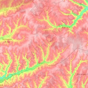
Nom : Carte topographique Арский район, altitude, relief.
Lieu : Арский район, Tatarstan, Föderationskreis Wolga, Russland (55.91020 49.50106 56.53721 50.30046)
Altitude moyenne : 154 m
Altitude minimum : 68 m
Altitude maximum : 207 m
Autres cartes topographiques
Cliquez sur une carte pour visualiser sa topographie, son altitude et son relief.
Kuibyschewer Stausee
Russland > Tatarstan > Краснослободское сельское поселение
Kuibyschewer Stausee, Краснослободское сельское поселение, Спасский район, Tatarstan, Föderationskreis Wolga, Russland
Altitude moyenne : 114 m
Nischnekamsker Stausee
Russland > Tatarstan > Малошильнинское сельское поселение
Nischnekamsker Stausee, Малошильнинское сельское поселение, Тукаевский район, Tatarstan, Föderationskreis Wolga, Russland
Altitude moyenne : 129 m