
Carte topographique West Windsor
Carte interactive
Cliquez sur la carte pour afficher l’altitude.
À propos de cette carte
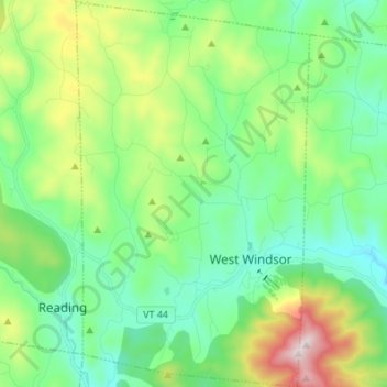
Nom : Carte topographique West Windsor, altitude, relief.
Lieu : West Windsor, Windsor County, Vermont, 05037, United States (43.43519 -72.53283 43.53387 -72.45051)
Altitude moyenne : 366 m
Altitude minimum : 147 m
Altitude maximum : 945 m
The unincorporated village of Brownsville is one of the few urban areas in the town and sits at the northwestern base of Mount Ascutney (elevation 3143 ft.).[5]
Autres cartes topographiques
Cliquez sur une carte pour visualiser sa topographie, son altitude et son relief.
Woodstock
United States > Vermont > Windsor County > Woodstock
Woodstock, Windsor County, Vermont, United States
Altitude moyenne : 368 m
Windsor
United States > Vermont > Windsor County > Windsor
Windsor, Windsor County, Vermont, 05089, United States
Altitude moyenne : 257 m