
Carte topographique Pelican Island
Carte interactive
Cliquez sur la carte pour afficher l’altitude.
À propos de cette carte
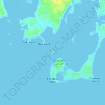
Nom : Carte topographique Pelican Island, altitude, relief.
Lieu : Pelican Island, Greenwich, Fairfield, Connecticut, USA (41.00827 -73.58558 41.00928 -73.58432)
Altitude moyenne : 1 m
Altitude minimum : -1 m
Altitude maximum : 21 m
Autres cartes topographiques
Cliquez sur une carte pour visualiser sa topographie, son altitude et son relief.
Greenwich Harbor
USA > Connecticut > Greenwich
Greenwich Harbor, Steamboat Road, Greenwich, Fairfield, Connecticut, 06830, USA
Altitude moyenne : 14 m
Audubon Greenwich
USA > Connecticut > Greenwich
Audubon Greenwich, John Street, Greenwich, Fairfield, Connecticut, 10504:10506, USA
Altitude moyenne : 132 m
Island Beach
USA > Connecticut > Greenwich
Island Beach, Greenwich, Fairfield, Connecticut, USA
Altitude moyenne : 0 m
Red Rock
USA > Connecticut > Greenwich
Red Rock, Greenwich, Fairfield, Connecticut, 06876, USA
Altitude moyenne : 56 m