
Carte topographique Újrónafő
Carte interactive
Cliquez sur la carte pour afficher l’altitude.
À propos de cette carte
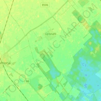
Nom : Carte topographique Újrónafő, altitude, relief.
Altitude moyenne : 116 m
Altitude minimum : 109 m
Altitude maximum : 122 m
Autres cartes topographiques
Cliquez sur une carte pour visualiser sa topographie, son altitude et son relief.
Fertőrákos
Hungary > Győr-Moson-Sopron > Fertőrákos
Fertőrákos, Soproni járás, Győr-Moson-Sopron, Western Transdanubia, Transdanubia, 9421, Hungary
Altitude moyenne : 153 m