
Faire un don
Équipez-vous pour votre prochaine aventure :
En tant que Partenaire Amazon, ce site perçoit une commission sur les achats éligibles sans surcoût pour vous.
Carte topographique Kumbrabow State Forest
Cliquez sur la carte pour afficher l’altitude.
Faire un don
Équipez-vous pour votre prochaine aventure :
En tant que Partenaire Amazon, ce site perçoit une commission sur les achats éligibles sans surcoût pour vous.
À propos de cette carte
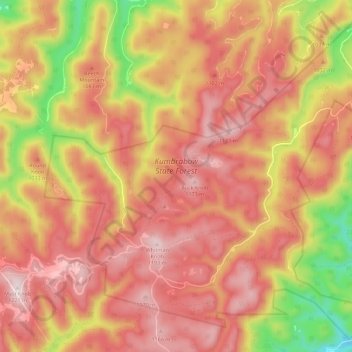
Nom : Carte topographique Kumbrabow State Forest, altitude, relief.
Altitude moyenne : 1 013 m
Altitude minimum : 692 m
Altitude maximum : 1 205 m
Faire un don
Équipez-vous pour votre prochaine aventure :
En tant que Partenaire Amazon, ce site perçoit une commission sur les achats éligibles sans surcoût pour vous.
Autres cartes topographiques
Cliquez sur une carte pour visualiser sa topographie, son altitude et son relief.
Faire un don
Équipez-vous pour votre prochaine aventure :
En tant que Partenaire Amazon, ce site perçoit une commission sur les achats éligibles sans surcoût pour vous.
Bickle Knob
United States > West Virginia > Randolph County
Bickle Knob is located at the end of Forest Route 91A, a spur from Stuart Memorial Drive (FR 91). Both roads are gravel but can easily be traversed by normal passenger cars. Stuart Memorial Drive is a scenic path as it traces the edge of the Shavers Fork canyon. Due to the high elevation of the area and the…
Altitude moyenne : 982 m
Faire un don
Équipez-vous pour votre prochaine aventure :
En tant que Partenaire Amazon, ce site perçoit une commission sur les achats éligibles sans surcoût pour vous.