
Carte topographique Unorganized Thunder Bay District
Carte interactive
Cliquez sur la carte pour afficher l’altitude.
À propos de cette carte
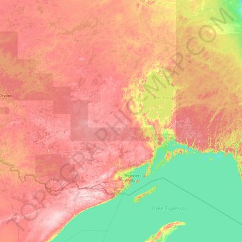
Nom : Carte topographique Unorganized Thunder Bay District, altitude, relief.
Altitude moyenne : 344 m
Altitude minimum : 175 m
Altitude maximum : 678 m
Autres cartes topographiques
Cliquez sur une carte pour visualiser sa topographie, son altitude et son relief.
Savanne River
Kanada > Ontario > Thunder Bay District > Unorganized Thunder Bay District
Savanne River, Unorganized Thunder Bay District, Thunder Bay District, Northwestern Ontario, Ontario, Kanada
Altitude moyenne : 468 m