
Carte topographique Lake Rotongata (Mirror Lake)
Carte interactive
Cliquez sur la carte pour afficher l’altitude.
À propos de cette carte
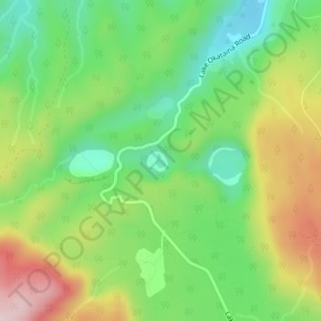
Nom : Carte topographique Lake Rotongata (Mirror Lake), altitude, relief.
Altitude moyenne : 432 m
Altitude minimum : 289 m
Altitude maximum : 644 m
Autres cartes topographiques
Cliquez sur une carte pour visualiser sa topographie, son altitude et son relief.
Lake Ngawhero
New Zealand > Bay of Plenty > Ruato
Lake Ngawhero, Curtis Road, Ruato, Rotorua District, Bay of Plenty, New Zealand
Altitude moyenne : 309 m