
Carte topographique Kwun Tong District
Carte interactive
Cliquez sur la carte pour afficher l’altitude.
À propos de cette carte
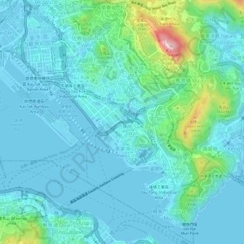
Nom : Carte topographique Kwun Tong District, altitude, relief.
Lieu : Kwun Tong District, Kowloon, Hong Kong, China (22.28228 114.20171 22.33496 114.24558)
Altitude moyenne : 61 m
Altitude minimum : -23 m
Altitude maximum : 399 m
Autres cartes topographiques
Cliquez sur une carte pour visualiser sa topographie, son altitude et son relief.
Kowloon Walled City Park
Kowloon Walled City Park, Kau Pui Shek, Kowloon City, Kowloon City District, Kowloon, Hong Kong, China
Altitude moyenne : 28 m
Jordan Valley
Jordan Valley, Shun On Road, Choi Wan, Jordan Valley, Kowloon, Kwun Tong District, Hong Kong, China
Altitude moyenne : 107 m
Kowloon City District
Kowloon City District, Kowloon, Hong Kong, China
Altitude moyenne : 37 m