
Carte topographique Newark
Carte interactive
Cliquez sur la carte pour afficher l’altitude.
À propos de cette carte
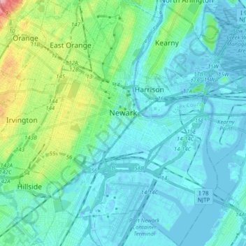
Nom : Carte topographique Newark, altitude, relief.
Lieu : Newark, Essex County, New Jersey, United States (40.67325 -74.25133 40.78814 -74.11418)
Altitude moyenne : 22 m
Altitude minimum : -11 m
Altitude maximum : 131 m
According to the United States Census Bureau, the city had a total area of 25.89 square miles (67.1 km2), including 24.14 square miles (62.5 km2) of land and 1.74 square miles (4.5 km2) of water (6.72%). It has the third-smallest land area among the 100 most populous cities in the U.S., behind neighboring Jersey City and Hialeah, Florida. The city's altitude ranges from 0 (sea level) in the east to approximately 230 feet (70 m) above sea level in the western section of the city. Newark is essentially a large basin sloping towards the Passaic River, with a few valleys formed by meandering streams. Historically, Newark's high places have been its wealthier neighborhoods. In the 19th century and early 20th century, the wealthy congregated on the ridges of Forest Hill, High Street, and Weequahic.
Autres cartes topographiques
Cliquez sur une carte pour visualiser sa topographie, son altitude et son relief.
Millburn
United States > New Jersey > Essex County
Millburn, Essex County, New Jersey, United States
Altitude moyenne : 88 m
Glen Ridge
United States > New Jersey > Essex County > Glen Ridge
Glen Ridge, Essex County, New Jersey, 07028, United States
Altitude moyenne : 71 m
West Caldwell
United States > New Jersey > Essex County
West Caldwell, Essex County, New Jersey, 07006, United States
Altitude moyenne : 76 m
Short Hills
United States > New Jersey > Essex County > Short Hills
Short Hills, Millburn, Essex County, New Jersey, 07078, United States
Altitude moyenne : 98 m