
Carte topographique Gwari
Carte interactive
Cliquez sur la carte pour afficher l’altitude.
À propos de cette carte
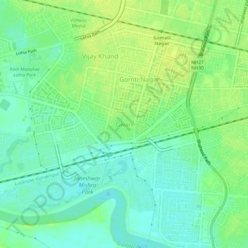
Nom : Carte topographique Gwari, altitude, relief.
Lieu : Gwari, Lucknow, Lucknow District, Uttar Pradesh, 226010, India (26.82561 80.97607 26.86561 81.01607)
Altitude moyenne : 113 m
Altitude minimum : 104 m
Altitude maximum : 121 m
Autres cartes topographiques
Cliquez sur une carte pour visualiser sa topographie, son altitude et son relief.
Lucknow
India > Uttar Pradesh > Lucknow
Lucknow, Lucknow District, Uttar Pradesh, 226027, India
Altitude moyenne : 120 m
Vikram Nagar
India > Uttar Pradesh > Lucknow
Vikram Nagar, Lucknow, Lucknow District, Uttar Pradesh, 226008, India
Altitude moyenne : 124 m
Tiwariganj
India > Uttar Pradesh > Lucknow
Tiwariganj, Lucknow, Lucknow District, Uttar Pradesh, 226028, India
Altitude moyenne : 117 m
बड़ा भरवांरा
India > Uttar Pradesh > Lucknow
बड़ा भरवांरा, Lucknow, Uttar Pradesh, 227105, India
Altitude moyenne : 115 m