
Carte topographique Morehead
Carte interactive
Cliquez sur la carte pour afficher l’altitude.
À propos de cette carte
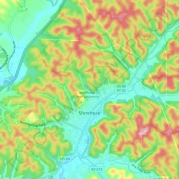
Nom : Carte topographique Morehead, altitude, relief.
Lieu : Morehead, Rowan County, Kentucky, 40351, United States (38.16309 -83.49611 38.22257 -83.40844)
Altitude moyenne : 287 m
Altitude minimum : 207 m
Altitude maximum : 413 m
Morehead is in the foothills of the Appalachian Mountains. The topography of the area represents a mixture of the Highland Rim and the western border of the Eastern Kentucky Coalfield. The highest elevation in the county is Limestone Knob (1435 ft), situated approximately 3 miles southwest of Morehead. The elevation of the city is 748 ft.