
Carte topographique Spiekeroog
Carte interactive
Cliquez sur la carte pour afficher l’altitude.
À propos de cette carte
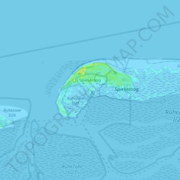
Nom : Carte topographique Spiekeroog, altitude, relief.
Lieu : Spiekeroog, Landkreis Wittmund, Lower Saxony, 26474, Germany (53.74969 7.66598 53.78232 7.81724)
Altitude moyenne : 0 m
Altitude minimum : -2 m
Altitude maximum : 16 m
Autres cartes topographiques
Cliquez sur une carte pour visualiser sa topographie, son altitude et son relief.
Wold
Germany > Lower Saxony > Landkreis Wittmund > Holtgast
Wold, Holtgast, Samtgemeinde Esens, Landkreis Wittmund, Lower Saxony, 26427, Germany
Altitude moyenne : 2 m
Friedeburg
Germany > Lower Saxony > Landkreis Wittmund
Friedeburg, Landkreis Wittmund, Lower Saxony, 26446, Germany
Altitude moyenne : 7 m
Esens
Germany > Lower Saxony > Landkreis Wittmund
Esens, Samtgemeinde Esens, Landkreis Wittmund, Lower Saxony, Germany
Altitude moyenne : 1 m
Werdum
Germany > Lower Saxony > Landkreis Wittmund
Werdum, Samtgemeinde Esens, Landkreis Wittmund, Lower Saxony, Germany
Altitude moyenne : -1 m
Spiekeroog
Germany > Lower Saxony > Landkreis Wittmund > Spiekeroog
Spiekeroog, Landkreis Wittmund, Lower Saxony, 26474, Germany
Altitude moyenne : 0 m