
Carte topographique Landgoed Hoekelum
Carte interactive
Cliquez sur la carte pour afficher l’altitude.
À propos de cette carte
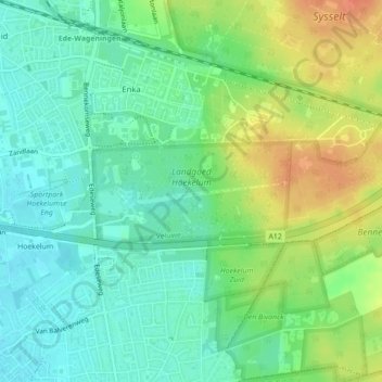
Nom : Carte topographique Landgoed Hoekelum, altitude, relief.
Altitude moyenne : 30 m
Altitude minimum : 13 m
Altitude maximum : 56 m
Autres cartes topographiques
Cliquez sur une carte pour visualiser sa topographie, son altitude et son relief.
De Kraats
Nederland > Gelderland > Bennekom
De Kraats, Bennekom, Ede, Gelderland, Nederland, 6721 NJ, Nederland
Altitude moyenne : 10 m
Hoekelum
Nederland > Gelderland > Bennekom
Hoekelum, Bennekom, Ede, Gelderland, Nederland, 6721 ML, Nederland
Altitude moyenne : 21 m