
Carte topographique Southern Alps / Kā Tiritiri o te Moana
Carte interactive
Cliquez sur la carte pour afficher l’altitude.
À propos de cette carte
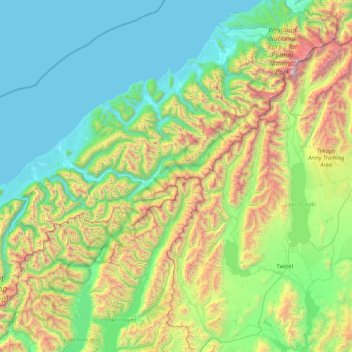
Nom : Carte topographique Southern Alps / Kā Tiritiri o te Moana, altitude, relief.
Altitude moyenne : 771 m
Altitude minimum : -1 m
Altitude maximum : 3 708 m
Autres cartes topographiques
Cliquez sur une carte pour visualiser sa topographie, son altitude et son relief.
Parc national de Kahurangi
Parc national de Kahurangi, West Coast, Nouvelle-Zélande
Altitude moyenne : 338 m
Mount Russel
Nouvelle-Zélande > West Coast > Westland District
Mount Russel, Westland District, West Coast, Nouvelle-Zélande
Altitude moyenne : 1 384 m
Amherst Glacier
Nouvelle-Zélande > West Coast > Westland District
Amherst Glacier, Westland District, West Coast, Nouvelle-Zélande
Altitude moyenne : 1 819 m
Franz Josef
Nouvelle-Zélande > West Coast > Westland District > Franz Josef / Waiau
Franz Josef, Fox Glacier Highway, Franz Josef / Waiau, Westland District, West Coast, 7856, Nouvelle-Zélande
Altitude moyenne : 159 m
Greymouth
Nouvelle-Zélande > West Coast > Grey District
Greymouth, Grey District, West Coast, 7801, Nouvelle-Zélande
Altitude moyenne : 40 m