
Carte topographique Marion
Carte interactive
Cliquez sur la carte pour afficher l’altitude.
À propos de cette carte
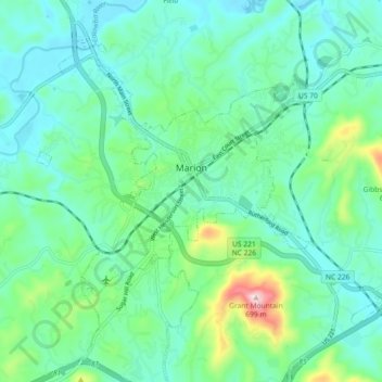
Nom : Carte topographique Marion, altitude, relief.
Altitude moyenne : 435 m
Altitude minimum : 365 m
Altitude maximum : 690 m
With an elevation of 1,400 feet, Marion's climate is fairly warm during summer (which are typically longer than lower elevation areas in the United States that get the same average high and low temperatures in the summer), when temperatures tend to be in the 80s and 90s, and moderately cold during the winter, with temperatures typically in the 30s and 40s.
Autres cartes topographiques
Cliquez sur une carte pour visualiser sa topographie, son altitude et son relief.
West Marion
United States > North Carolina > McDowell County
West Marion, McDowell County, North Carolina, 28752, United States
Altitude moyenne : 449 m
Nebo
United States > North Carolina > McDowell County
Nebo, McDowell County, North Carolina, 28761, United States
Altitude moyenne : 394 m
Little Switzerland
United States > North Carolina > McDowell County
Little Switzerland, McDowell County, North Carolina, 28749, United States
Altitude moyenne : 935 m
Old Fort
United States > North Carolina > McDowell County
Old Fort, McDowell County, North Carolina, United States
Altitude moyenne : 474 m