
Carte topographique John Day Fossil Beds National Monument
Carte interactive
Cliquez sur la carte pour afficher l’altitude.
John Day Fossil Beds National Monument
Averaging about 2,200 feet (670 m) in elevation, the monument has a dry climate with temperatures that vary from summer highs of about 90 °F (32 °C) to winter lows below freezing. The monument has more than 80 soil types that support a wide variety of flora, ranging from willow trees near the river to grasses on alluvial fans to cactus among rocks at higher elevations. Fauna include more than 50 species of resident and migratory birds. Large mammals like elk and smaller animals such as raccoons, coyotes, and voles frequent these units, which are also populated by a wide variety of reptiles, fish, butterflies, and other creatures adapted to particular niches of a mountainous semi-desert terrain.
À propos de cette carte
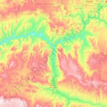
Nom : Carte topographique John Day Fossil Beds National Monument, altitude, relief.
Altitude moyenne : 1 136 m
Altitude minimum : 500 m
Altitude maximum : 1 922 m