
Carte topographique Wold Newton
Carte interactive
Cliquez sur la carte pour afficher l’altitude.
À propos de cette carte
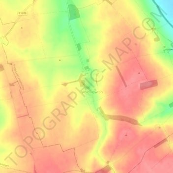
Nom : Carte topographique Wold Newton, altitude, relief.
Altitude moyenne : 94 m
Altitude minimum : 38 m
Altitude maximum : 120 m
Autres cartes topographiques
Cliquez sur une carte pour visualiser sa topographie, son altitude et son relief.
Hawerby
United Kingdom > England > Wold Newton > Hawerby
Hawerby, Wold Newton, North East Lincolnshire, Yorkshire and the Humber, England, DN36 5PX, United Kingdom
Altitude moyenne : 62 m