
Faire un don
Équipez-vous pour votre prochaine aventure :
En tant que Partenaire Amazon, ce site perçoit une commission sur les achats éligibles sans surcoût pour vous.
Carte topographique Palm Coast
Cliquez sur la carte pour afficher l’altitude.
Faire un don
Équipez-vous pour votre prochaine aventure :
En tant que Partenaire Amazon, ce site perçoit une commission sur les achats éligibles sans surcoût pour vous.
Palm Coast
Palm Coast features a diverse and relatively flat topography, characterized by its coastal plain terrain, which gently slopes towards the Atlantic Ocean. The elevation typically ranges from about 10 to 30 feet above sea level, providing a subtle gradient that contributes to its scenic views. The area is interspersed with numerous freshwater canals, marshes, and ponds, enhancing its natural beauty and supporting a rich ecosystem. Dense clusters of subtropical vegetation, including palm trees and pines, add to the landscape, while nearby salt marshes and the sandy beaches provide unique coastal environments. Overall, Palm Coast's topography reflects a harmonious blend of inland wetlands and coastal features, making it a picturesque location for residents and visitors alike.
Faire un don
Équipez-vous pour votre prochaine aventure :
En tant que Partenaire Amazon, ce site perçoit une commission sur les achats éligibles sans surcoût pour vous.
À propos de cette carte
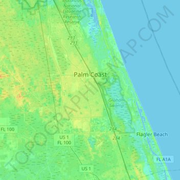
Nom : Carte topographique Palm Coast, altitude, relief.
Lieu : Palm Coast, Flagler County, Florida, United States (29.41410 -81.37164 29.65180 -81.14878)
Altitude moyenne : 6 m
Altitude minimum : -4 m
Altitude maximum : 20 m
Faire un don
Équipez-vous pour votre prochaine aventure :
En tant que Partenaire Amazon, ce site perçoit une commission sur les achats éligibles sans surcoût pour vous.
Autres cartes topographiques
Cliquez sur une carte pour visualiser sa topographie, son altitude et son relief.
Faire un don
Équipez-vous pour votre prochaine aventure :
En tant que Partenaire Amazon, ce site perçoit une commission sur les achats éligibles sans surcoût pour vous.