Géolocaliser

Carte topographique Harles

Carte interactive

Cliquez sur la carte pour afficher l’altitude.

À propos de cette carte

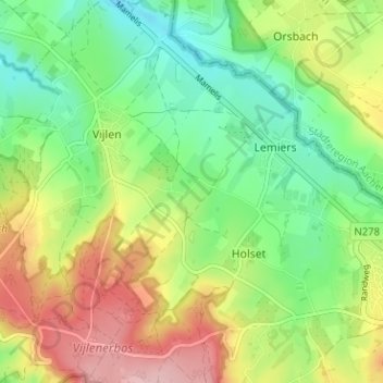
Nom : Carte topographique Harles, altitude, relief.

Lieu : Harles, Vijlen, Vaals, Limburg, Nederland, 6294 NG, Nederland (50.76162 5.95838 50.80162 5.99838)

Altitude moyenne : 194 m

Altitude minimum : 125 m

Altitude maximum : 296 m

Autres cartes topographiques

Cliquez sur une carte pour visualiser sa topographie, son altitude et son relief.

Camerig

Nederland > Limburg > Vijlen

Camerig, Vijlen, Vaals, Limburg, Nederland, 6294 NB, Nederland

Altitude moyenne : 166 m

Vijlen

Nederland > Limburg > Vijlen

Vijlen, Limburg, Nederland, 6294, Nederland

Altitude moyenne : 180 m

Rott

Nederland > Limburg > Vijlen > Rott

Rott, Vijlen, Vaals, Limburg, Nederland, 6294, Nederland

Altitude moyenne : 167 m

Cottessen

Nederland > Limburg > Vijlen

Cottessen, Vijlen, Vaals, Limburg, Nederland, 6294 NE, Nederland

Altitude moyenne : 183 m