
Carte topographique Bishop's Stortford
Carte interactive
Cliquez sur la carte pour afficher l’altitude.
À propos de cette carte
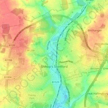
Nom : Carte topographique Bishop's Stortford, altitude, relief.
Altitude moyenne : 83 m
Altitude minimum : 52 m
Altitude maximum : 111 m
Stortford, along with the rest of Britain, has a temperate maritime climate, with cool summers and mild winters. The nearest weather station for which averages and extremes are available is Stansted Airport, about .mw-parser-output .frac{white-space:nowrap}.mw-parser-output .frac .num,.mw-parser-output .frac .den{font-size:80%;line-height:0;vertical-align:super}.mw-parser-output .frac .den{vertical-align:sub}.mw-parser-output .sr-only{border:0;clip:rect(0,0,0,0);height:1px;margin:-1px;overflow:hidden;padding:0;position:absolute;width:1px}2+1⁄2 miles (4 kilometres) due east of Stortford's town centre. Located at an elevation of over 100 m, the weather station, and parts of Stortford in general are marginally cooler throughout the year than the Cambridgeshire area to the north or the London area to the south. Nonetheless, Stortford is still warmer than the English average.
Autres cartes topographiques
Cliquez sur une carte pour visualiser sa topographie, son altitude et son relief.
Gilston
United Kingdom > England > Hertfordshire > East Hertfordshire > Gilston
Gilston, East Hertfordshire, Hertfordshire, England, United Kingdom
Altitude moyenne : 59 m
Wakeley
United Kingdom > England > Hertfordshire > East Hertfordshire > Buntingford > Westmill > Wakeley
Wakeley, Westmill, Buntingford, East Hertfordshire, Hertfordshire, East of England, England, SG9 9NH, United Kingdom
Altitude moyenne : 121 m