
Carte topographique Cuyahoga River
Carte interactive
Cliquez sur la carte pour afficher l’altitude.
Cuyahoga River
The upper Cuyahoga River, starting at 1,093 feet (333 m) over 84 miles (135 km) from its mouth, drops in elevation fairly steeply, creating falls and rapids in some places; the lower Cuyahoga River only drops several feet along the last several miles of the lower river to 571 feet (174 m) at the mouth on Lake Erie, resulting in relatively slow-moving waters that can take a while to drain compared to the upper Cuyahoga.
À propos de cette carte
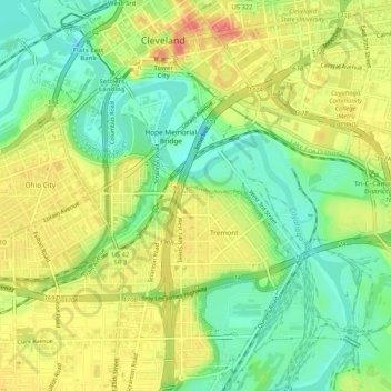
Nom : Carte topographique Cuyahoga River, altitude, relief.
Altitude moyenne : 196 m
Altitude minimum : 165 m
Altitude maximum : 230 m
Autres cartes topographiques
Cliquez sur une carte pour visualiser sa topographie, son altitude et son relief.
Cleveland
United States > Ohio > Cuyahoga County > Cleveland
The land rises quickly from the lake shore elevation of 569 feet. Public Square, less than one mile (1.6 km) inland, sits at an elevation of 650 feet (198 m), and Hopkins Airport, 5 miles (8 km) inland from the lake, is at an elevation of 791 feet (241 m).
Altitude moyenne : 221 m