
Carte topographique Windermere Island
Carte interactive
Cliquez sur la carte pour afficher l’altitude.
À propos de cette carte
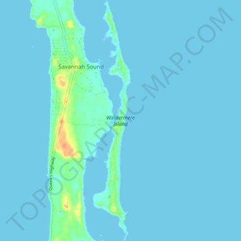
Nom : Carte topographique Windermere Island, altitude, relief.
Lieu : Windermere Island, Central Eleuthera, The Bahamas (25.03481 -76.12671 25.10605 -76.11428)
Altitude moyenne : 3 m
Altitude minimum : 0 m
Altitude maximum : 39 m
Autres cartes topographiques
Cliquez sur une carte pour visualiser sa topographie, son altitude et son relief.
North Palmetto Point
The Bahamas > Central Eleuthera
North Palmetto Point, Central Eleuthera, The Bahamas
Altitude moyenne : 9 m
Savannah Sound
The Bahamas > Central Eleuthera
Savannah Sound, Central Eleuthera, The Bahamas
Altitude moyenne : 5 m