
Carte topographique Utah County
Carte interactive
Cliquez sur la carte pour afficher l’altitude.
À propos de cette carte
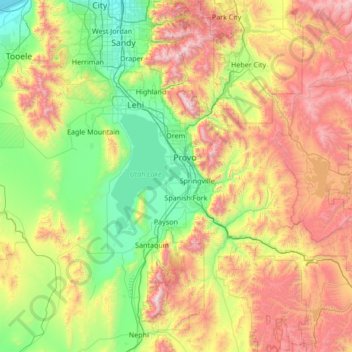
Nom : Carte topographique Utah County, altitude, relief.
Lieu : Utah County, Utah, United States of America (39.77736 -112.21283 40.57791 -110.85765)
Altitude moyenne : 2 062 m
Altitude minimum : 1 283 m
Altitude maximum : 3 581 m
Utah Valley lies at the center of the county, lined by the mountains of the Wasatch Range on the east. Utah Lake occupies a large part of the valley. The elevation ranges from 4,487 feet (1,368 m) above sea level at the lake to 11,928 feet (3,636 m) at the peak of Mount Nebo.
Autres cartes topographiques
Cliquez sur une carte pour visualiser sa topographie, son altitude et son relief.
Daggett County
United States of America > Utah
Daggett County, Utah, 84023, United States of America
Altitude moyenne : 2 267 m
Tooele County
United States of America > Utah
Tooele County, Utah, United States of America
Altitude moyenne : 1 462 m
Duchesne County
United States of America > Utah
Duchesne County, Utah, United States of America
Altitude moyenne : 2 408 m