
Carte topographique Watertown Charter Township
Carte interactive
Cliquez sur la carte pour afficher l’altitude.
À propos de cette carte
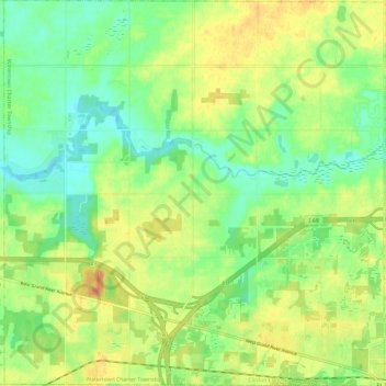
Nom : Carte topographique Watertown Charter Township, altitude, relief.
Altitude moyenne : 255 m
Altitude minimum : 236 m
Altitude maximum : 277 m
Autres cartes topographiques
Cliquez sur une carte pour visualiser sa topographie, son altitude et son relief.
Dallas Township
United States > Michigan > Clinton County
Dallas Township, Clinton County, Michigan, United States
Altitude moyenne : 225 m
Bath Charter Township
United States > Michigan > Clinton County
Bath Charter Township, Clinton County, Michigan, 48808, United States
Altitude moyenne : 256 m
St. Johns
United States > Michigan > Clinton County > St. Johns
St. Johns, Clinton County, Michigan, 48879, United States
Altitude moyenne : 229 m
Lake Victoria
United States > Michigan > Clinton County > Westchester Heights
Lake Victoria, Westchester Heights, Victor Township, Clinton County, Michigan, United States
Altitude moyenne : 249 m
Lebanon Township
United States > Michigan > Clinton County
Lebanon Township, Clinton County, Michigan, United States
Altitude moyenne : 220 m
DeWitt
United States > Michigan > Clinton County
DeWitt, Clinton County, Michigan, 48820, United States
Altitude moyenne : 256 m