
Carte topographique Teteven
Carte interactive
Cliquez sur la carte pour afficher l’altitude.
À propos de cette carte
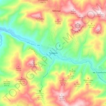
Nom : Carte topographique Teteven, altitude, relief.
Lieu : Teteven, Lovech, Bulgaria (42.87837 24.22354 42.95837 24.30354)
Altitude moyenne : 762 m
Altitude minimum : 365 m
Altitude maximum : 1 224 m
Teteven is located in a mountainous area, in the foothills of the Balkan mountains between the peaks Ostrich, Petrahilya, Cherven, Treskavets and Vezhen. The river Vit meanders through the town. The altitude of Teteven district varies from 340 to 2100 m, and in the town center it is 415 m. The climate is temperate continental with cold winters and cool summers. The territory of Teteven is about 697 km², which is 16.86% of the territory of Lovech district.
Autres cartes topographiques
Cliquez sur une carte pour visualiser sa topographie, son altitude et son relief.