
Carte topographique Berwick-upon-Tweed
Carte interactive
Cliquez sur la carte pour afficher l’altitude.
À propos de cette carte
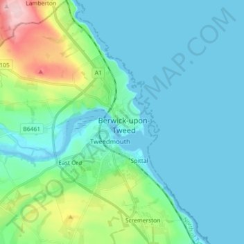
Nom : Carte topographique Berwick-upon-Tweed, altitude, relief.
Altitude moyenne : 35 m
Altitude minimum : -1 m
Altitude maximum : 197 m
In the 1840s, Samuel Lewis included similar entries for Berwick-upon-Tweed in both his England and Scotland Topographical Dictionary. Berwick remained a county in its own right, and was not included in Northumberland for Parliamentary purposes until 1885. In the same year, the Redistribution of Seats Act reduced the number of Members of Parliament (MPs) returned by the town from two to one.