
Faire un don
Équipez-vous pour votre prochaine aventure :
En tant que Partenaire Amazon, ce site perçoit une commission sur les achats éligibles sans surcoût pour vous.
Carte topographique Palm Beach
Cliquez sur la carte pour afficher l’altitude.
Faire un don
Équipez-vous pour votre prochaine aventure :
En tant que Partenaire Amazon, ce site perçoit une commission sur les achats éligibles sans surcoût pour vous.
Palm Beach
Palm Beach is one of the easternmost towns in Florida, though the state's easternmost point is in Palm Beach Shores, just north of Lake Worth Inlet. The town is on an 18-mile (29 km) long barrier island between the Intracoastal Waterway (locally known as the Lake Worth Lagoon) on the west and the Atlantic Ocean on the east. At no point is the island wider than three-quarters of a mile (1.2 km), and in places it is only 500 feet (150 m) wide. The northern boundary of Palm Beach is the Lake Worth Inlet, though it adjoined with Singer Island until the permanent dredging of the inlet in 1918. To the south, a section of Lake Worth Beach occupies the island in the vicinity of State Road 802, though an exclave of Palm Beach extends farther southward until the northern limits of South Palm Beach. According to the U.S. Census Bureau, the town has an area of 8.12 sq mi (21.0 km2), with land accounting for 4.20 sq mi (10.9 km2) and water covering the remaining 3.92 sq mi (10.2 km2). The average elevation of the town is 7 ft (2.1 m); the highest point is 30 ft (9.1 m) above sea level on the golf course at the Palm Beach Country Club.
Faire un don
Équipez-vous pour votre prochaine aventure :
En tant que Partenaire Amazon, ce site perçoit une commission sur les achats éligibles sans surcoût pour vous.
À propos de cette carte
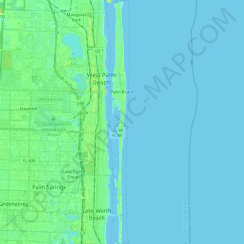
Nom : Carte topographique Palm Beach, altitude, relief.
Lieu : Palm Beach, Palm Beach County, Florida, 33480, United States (26.59392 -80.04906 26.77262 -80.03036)
Altitude moyenne : 4 m
Altitude minimum : -1 m
Altitude maximum : 26 m
Faire un don
Équipez-vous pour votre prochaine aventure :
En tant que Partenaire Amazon, ce site perçoit une commission sur les achats éligibles sans surcoût pour vous.
Autres cartes topographiques
Cliquez sur une carte pour visualiser sa topographie, son altitude et son relief.
Faire un don
Équipez-vous pour votre prochaine aventure :
En tant que Partenaire Amazon, ce site perçoit une commission sur les achats éligibles sans surcoût pour vous.
Faire un don
Équipez-vous pour votre prochaine aventure :
En tant que Partenaire Amazon, ce site perçoit une commission sur les achats éligibles sans surcoût pour vous.
Faire un don
Équipez-vous pour votre prochaine aventure :
En tant que Partenaire Amazon, ce site perçoit une commission sur les achats éligibles sans surcoût pour vous.
Faire un don
Équipez-vous pour votre prochaine aventure :
En tant que Partenaire Amazon, ce site perçoit une commission sur les achats éligibles sans surcoût pour vous.
Delray Beach
United States > Florida > Palm Beach County > Delray Beach
Delray Beach has hot and humid summers. High summertime temperatures range from 87-93 °F with low temperatures around 75-78 °F. Winters are warm, with a marked drier season. Typical wintertime high temperatures are typically in the range of 74-83 °F and low temperatures 57-65 °F. However, when occasional…
Altitude moyenne : 4 m
Villages of Oriole
United States > Florida > Palm Beach County > Villages of Oriole
Altitude moyenne : 9 m
Faire un don
Équipez-vous pour votre prochaine aventure :
En tant que Partenaire Amazon, ce site perçoit une commission sur les achats éligibles sans surcoût pour vous.
Blue Inlet
United States > Florida > Palm Beach County > Boca Raton > Blue Inlet
Altitude moyenne : 4 m
Oslo national park
United States > Florida > Palm Beach County > West Palm Beach
Altitude moyenne : 9 m
Faire un don
Équipez-vous pour votre prochaine aventure :
En tant que Partenaire Amazon, ce site perçoit une commission sur les achats éligibles sans surcoût pour vous.