
Carte topographique Donegal Municipal District
Carte interactive
Cliquez sur la carte pour afficher l’altitude.
À propos de cette carte
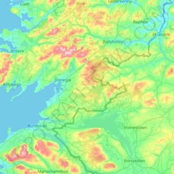
Nom : Carte topographique Donegal Municipal District, altitude, relief.
Lieu : Donegal Municipal District, County Donegal, Ulster, Irlande (54.45905 -8.83471 54.79033 -7.69348)
Altitude moyenne : 120 m
Altitude minimum : -2 m
Altitude maximum : 669 m
Autres cartes topographiques
Cliquez sur une carte pour visualiser sa topographie, son altitude et son relief.
Clonmany Civil Parish
Clonmany Civil Parish, County Donegal, Ulster, Irlande
Altitude moyenne : 92 m
Letterkenny Municipal District
Letterkenny Municipal District, County Donegal, Ulster, Irlande
Altitude moyenne : 92 m
Glencolumbkille
Glencolumbkille, County Donegal, Irlande
Altitude moyenne : 95 m
Illion
Illion, Aran ED, Glenties Municipal District, County Donegal, Irlande
Altitude moyenne : 59 m
Clonmany
Irlande > County Donegal > Clonmany
Clonmany, Inishowen Municipal District, County Donegal, F93 RRX6, Irlande
Altitude moyenne : 70 m