
Carte topographique Camden
Carte interactive
Cliquez sur la carte pour afficher l’altitude.
Camden
According to the U.S. Census Bureau, the town has a total area of 26.65 square miles (69.02 km2), of which, 18.24 square miles (47.24 km2) of it is land and 8.41 square miles (21.78 km2) is water. Drained by the Megunticook River, Camden is located beside Penobscot Bay and the Gulf of Maine, part of the Atlantic Ocean. Principal bodies of water include: Megunticook Lake, Hosmer Pond (54 acres), Impoundment (Seabright Pond) (74 acres) and Lily Pond (32 acres). Mount Megunticook has an elevation of 1385 feet (419 m).
À propos de cette carte
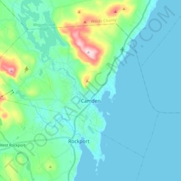
Nom : Carte topographique Camden, altitude, relief.
Lieu : Camden, Knox County, Maine, 04843, United States (44.17420 -69.16544 44.25946 -69.00469)
Altitude moyenne : 63 m
Altitude minimum : -2 m
Altitude maximum : 410 m