
Carte topographique Bennachie
Carte interactive
Cliquez sur la carte pour afficher l’altitude.
À propos de cette carte
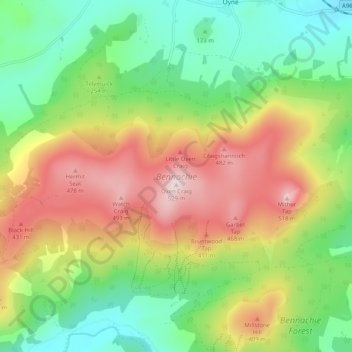
Nom : Carte topographique Bennachie, altitude, relief.
Lieu : Bennachie, Auchleven, Aberdeenshire, Scotland, United Kingdom (57.28142 -2.61815 57.30704 -2.51634)
Altitude moyenne : 262 m
Altitude minimum : 84 m
Altitude maximum : 516 m
Mither Tap has an astronomical alignment with the nearby Pictish Fortalice of Caskieben (currently located within Keith Hall). Dr. Arthur Johnston said "the hill of Benochie, a conical elevation about eight miles distant, casts its shadow over Caskieben at the periods of the equinox."