
Carte topographique Pszczyna
Carte interactive
Cliquez sur la carte pour afficher l’altitude.
À propos de cette carte
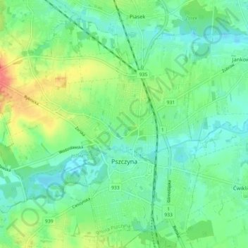
Nom : Carte topographique Pszczyna, altitude, relief.
Altitude moyenne : 254 m
Altitude minimum : 238 m
Altitude maximum : 287 m
Pszczyna is situated on sandy plains ascending into the east. The land is slightly hilly, but with no large relative elevations. The highest points are less than 260 metres (850 feet) above sea level.
Autres cartes topographiques
Cliquez sur une carte pour visualiser sa topographie, son altitude et son relief.
Mlyczek
Poland > Silesian Voivodeship > Pszczyna County > Łąka > Mlyczek
Mlyczek, Łąka, gmina Pszczyna, Pszczyna County, Silesian Voivodeship, 43-241, Poland
Altitude moyenne : 257 m