
Carte topographique Elizabethton
Carte interactive
Cliquez sur la carte pour afficher l’altitude.
À propos de cette carte
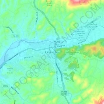
Nom : Carte topographique Elizabethton, altitude, relief.
Lieu : Elizabethton, Carter County, Tennessee, 37643, United States (36.30872 -82.25069 36.38872 -82.17069)
Altitude moyenne : 527 m
Altitude minimum : 444 m
Altitude maximum : 849 m
The elevation at Elizabethton Municipal Airport is 1,593 feet (486 m) ASL (the highest point of elevation in Carter County is at Roan Mountain with an elevation of 6,285 feet (1,916 m) ASL), and the airport is located on the eastern side of the city along State Highway 91 Stoney Creek Exit. Elizabethton is also connected to larger commercial, shuttle, and cargo flights out of Tri-Cities Regional Airport northwest of Johnson City.