
Carte topographique Tonatico
Carte interactive
Cliquez sur la carte pour afficher l’altitude.
À propos de cette carte
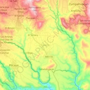
Nom : Carte topographique Tonatico, altitude, relief.
Lieu : Tonatico, State of Mexico, Mexico (18.72033 -99.71230 18.83346 -99.57373)
Altitude moyenne : 1 617 m
Altitude minimum : 1 201 m
Altitude maximum : 2 105 m
Tonatico has several nearby mountains, including La Cruz and Tapachichi. The largest is La Puerta at 1,685 meters of elevation. The Salto de Zumpantitlán waterfall is nearby, along with the Tenancingo, San Geronimo and Taplalla rivers.