
Carte topographique Ashstead Fell
Cliquez sur la carte pour afficher l’altitude.
À propos de cette carte
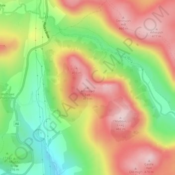
Nom : Carte topographique Ashstead Fell, altitude, relief.
Altitude moyenne : 326 m
Altitude minimum : 166 m
Altitude maximum : 477 m
Autres cartes topographiques
Cliquez sur une carte pour visualiser sa topographie, son altitude et son relief.
Windermere
United Kingdom > England > Cumbria > South Lakeland > Bowness-on-Windermere
There is debate as to whether the stretch of water between Newby Bridge and Lakeside at the southern end of the lake should be considered part of Windermere, or a navigable stretch of the River Leven. This affects the stated length of the lake, which is 11.23 miles (18.07 km) long if measured from the bridge…
Altitude moyenne : 132 m
Coniston Water
United Kingdom > England > Cumbria > South Lakeland > High Nibthwaite
Coniston Water in the English county of Cumbria is the third-largest lake in the Lake District by volume (after Windermere and Ullswater), and the fifth-largest by area. It is five miles long by half a mile wide (8 km by 800 m), has a maximum depth of 184 feet (56 m), and covers an area of 1.89 square miles…
Altitude moyenne : 186 m
Grasmere
United Kingdom > England > Cumbria > South Lakeland > Grasmere
The lake is 1680 yd (1540 m) long and 700 yd (640 m) wide, covering an area of 0.24 mi² (0.62 km²). It has a maximum depth of 70 ft (21m) and an elevation above sea level of 208 ft (62 m). The lake is both fed and drained by the River Rothay, which flows through the village before entering the lake, and then…
Altitude moyenne : 162 m
Whitestone Moss
United Kingdom > England > Cumbria > South Lakeland > High Nibthwaite > Houkler Hall
Altitude moyenne : 102 m
Deerbolts Wood
United Kingdom > England > Cumbria > South Lakeland > Elterwater
Altitude moyenne : 145 m