
Carte topographique Hitchin
Cliquez sur la carte pour afficher l’altitude.
À propos de cette carte
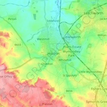
Nom : Carte topographique Hitchin, altitude, relief.
Altitude moyenne : 89 m
Altitude minimum : 45 m
Altitude maximum : 166 m
Autres cartes topographiques
Cliquez sur une carte pour visualiser sa topographie, son altitude et son relief.
Newnham
United Kingdom > England > Hertfordshire > North Hertfordshire > Baldock
Altitude moyenne : 69 m
Windmill Hill
United Kingdom > England > Hertfordshire > North Hertfordshire > Hitchin
Altitude moyenne : 74 m
Knebworth Country Park
United Kingdom > England > Hertfordshire > North Hertfordshire > Knebworth
Altitude moyenne : 116 m
St Paul's Walden
United Kingdom > England > Hertfordshire > North Hertfordshire
Altitude moyenne : 121 m
Ickleford
United Kingdom > England > Hertfordshire > North Hertfordshire > Hitchin
Altitude moyenne : 58 m
Ivel Springs Local Nature Reserve
United Kingdom > England > Hertfordshire > North Hertfordshire > Baldock
Altitude moyenne : 72 m
Long Pond
United Kingdom > England > Hertfordshire > North Hertfordshire > Offley > Offley Hoo
Altitude moyenne : 142 m
Knebworth Country Park
United Kingdom > England > Hertfordshire > North Hertfordshire > Knebworth
Altitude moyenne : 116 m