
Carte topographique Changzhi
Cliquez sur la carte pour afficher l’altitude.
Changzhi
Changzhi is located in southeastern Shanxi province, along the southern section of the Taihang Mountains. The majority of the city's area is mountainous, and much of the remaining geography is hilly in nature. The average elevation in the city is approximately 1,000 metres (3,300 ft) above sea level, with prominent peaks including Liyu Mountain (Chinese: 历峪山; pinyin: Lìyù Shān) and Shigao Mountain (Chinese: 石膏山; pinyin: Shígāo Shān), reaching 2,012 metres (6,601 ft) and 2,541 metres (8,337 ft) above sea level, respectively.
À propos de cette carte
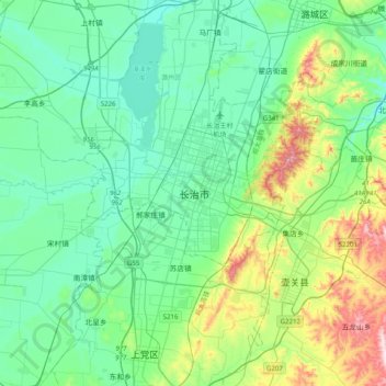
Nom : Carte topographique Changzhi, altitude, relief.
Altitude moyenne : 986 m
Altitude minimum : 870 m
Altitude maximum : 1 396 m