
Carte topographique Zuidlaren
Carte interactive
Cliquez sur la carte pour afficher l’altitude.
À propos de cette carte
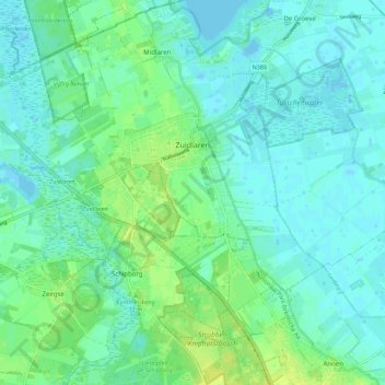
Nom : Carte topographique Zuidlaren, altitude, relief.
Lieu : Zuidlaren, Tynaarlo, Drenthe, Netherlands (53.06517 6.63964 53.10652 6.75028)
Altitude moyenne : 5 m
Altitude minimum : -4 m
Altitude maximum : 16 m
Autres cartes topographiques
Cliquez sur une carte pour visualiser sa topographie, son altitude et son relief.
Zuidbarge
Netherlands > Drenthe > Emmen
Zuidbarge, Emmen, Drenthe, Netherlands, 7825 TS, Netherlands
Altitude moyenne : 20 m
Lhee
Lhee, Dwingeloo, Westerveld, Drenthe, Netherlands, 7991 PK, Netherlands
Altitude moyenne : 11 m
De Kiel
Netherlands > Drenthe > Coevorden
De Kiel, Coevorden, Drenthe, Netherlands
Altitude moyenne : 19 m
Nieuw-Buinen
Nieuw-Buinen, Borger-Odoorn, Drenthe, Netherlands
Altitude moyenne : 7 m
Exloo
Netherlands > Drenthe > Borger-Odoorn
Exloo, Borger-Odoorn, Drenthe, Netherlands
Altitude moyenne : 17 m