
Carte topographique Winfield Township
Carte interactive
Cliquez sur la carte pour afficher l’altitude.
À propos de cette carte
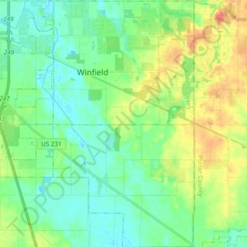
Nom : Carte topographique Winfield Township, altitude, relief.
Lieu : Winfield Township, Lake County, Indiana, United States (41.33307 -87.29707 41.43477 -87.21949)
Altitude moyenne : 220 m
Altitude minimum : 204 m
Altitude maximum : 251 m
Autres cartes topographiques
Cliquez sur une carte pour visualiser sa topographie, son altitude et son relief.
Lake Seven
United States > Indiana > Lake County > Crown Point
Lake Seven, Crown Point, Lake County, Indiana, United States
Altitude moyenne : 220 m
Lake Station
United States > Indiana > Lake County
Lake Station, Lake County, Indiana, 46405, United States
Altitude moyenne : 189 m
Glen Park
United States > Indiana > Lake County > Gary
Glen Park, Gary, Lake County, Indiana, 46409, United States
Altitude moyenne : 193 m
Miller
United States > Indiana > Lake County > Gary > Miller
Miller, Gary, Lake County, Indiana, 46403, United States
Altitude moyenne : 186 m
Hammond
United States > Indiana > Lake County
Hammond, Lake County, Indiana, United States
Altitude moyenne : 180 m
Munster
United States > Indiana > Lake County
Munster, Lake County, Indiana, 46321, United States
Altitude moyenne : 187 m
Griffith
United States > Indiana > Lake County > Griffith
Griffith, Lake County, Indiana, 46319, United States
Altitude moyenne : 190 m
Crown Point
United States > Indiana > Lake County > Crown Point
Crown Point, Lake County, Indiana, 46307, United States
Altitude moyenne : 220 m
Gary
United States > Indiana > Lake County > Gary
Gary, Lake County, Indiana, United States
Altitude moyenne : 185 m