
Carte topographique Rayong
Carte interactive
Cliquez sur la carte pour afficher l’altitude.
À propos de cette carte
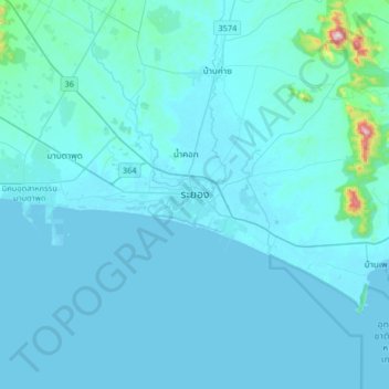
Nom : Carte topographique Rayong, altitude, relief.
Lieu : Rayong, Rayong Province, 21000, Thailand (12.52179 101.11777 12.84179 101.43777)
Altitude moyenne : 31 m
Altitude minimum : -3 m
Altitude maximum : 687 m
Autres cartes topographiques
Cliquez sur une carte pour visualiser sa topographie, son altitude et son relief.
Map Ta Phut
Thailand > Rayong Province > Rayong > Map Ta Phut > Ban Map Ta Phut
Map Ta Phut, Rayong, Rayong Province, 21150, Thailand
Altitude moyenne : 26 m